

Anthony Jenkinson and his revision of the cartographic schemes of Central Asia in the 16th century
DOI:
https://doi.org/10.69567/3007-0236.2023.1.22.55Keywords:
Anthony Jenkinson, Kitaia Lacus, Oxus, Jaxartes, Tashkent, Samarkand, Turkestan, Cassackia, Muscovy, Abraham OrteliusAbstract
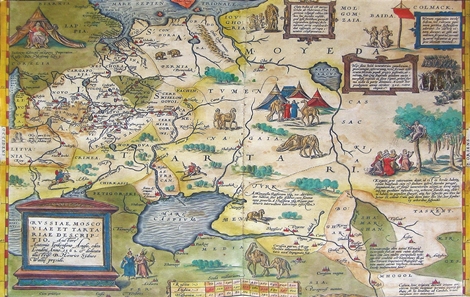
The article is devoted to the analysis of a new cartographic scheme of Central Asia of the 16th century, proposed by Anthony Jenkinson in his description of his journey through Russia and Central Asia in 1557–1559 (published in 1589) and in his map compiled with the help of cartographer Clement Adams and based on Russian and English documents, and his own observations. Jenkinson’s new cartographic scheme became widespreaddue to the copies of his map reproduced by many major cartographers, including Gerard Mercator and Abraham Ortelius. The original map was discovered only in the 1980s by the Polish researcher Kristina Szykula. The spatial organization scheme, on the one hand, partially remained true to the graphic line of Ptolemy (where the Oxus flows into the Caspian Sea), and, on the other hand, contained such toponyms as Tartaria, Turchestan, Persia, Corasan, India orientalis, China, Cathaio and Mongol, which had appeared in cartographic space thanks to many travelers. The revolutionary element of this scheme, according to the new positioning of Tashkent, Amu Darya, Syr Darya and Ob, were the following elements: 1) Amu Darya (Oxus) and Syr Darya (Jaxartes) are separated from the Caspian Sea; 2) they are related to Kitaia Lacus; 3) Kitaia Lacus can be interpreted as Aral; 4) Kitaia Lacusis connected with the river Oby (Ob); 5) the river Oby (Ob) is associated with Sur (Syr Darya) and Tashkent; 6) Kitaia Lacus is related to Cathay, which starts immediately east of the Ob and possibly describes not Ming Northern China, but Mongolia.A comparative analysis of the description of the journey and the copies of Jenkinson’s maps has shown the process of incorporating new knowledge about the region into the cartographic space and the stability of old schemes. The resulting compromise solution was reflected on the maps in the form of several layers of information and duplication of individual objects (thus, the Amu Darya is represented on the map twice: as Ougus (Ptolemy’s scheme) and as Amow (Jenkinson’s scheme)), double naming of one object (the Syr Darya acts simultaneously as Oby and as Sur) and deformation of space (Cathay is located near the island of Novaya Zemlya, on the proposed trade route from England to China).
References
Ahmedov, B. A. 1985. Istoriko-geograficheskaja literatura Srednej Azii XVI–XVIII vekov (Historical and geographical literature of Central Asia XVI–XVIII centuries). Tashkent: Fan (in Russian).
Alenicyn, V. 1880. Neskol'ko zamechanij o puteshestvii Dzhenkinsona v Hivu v 1559 godu (A few remarks about Jenkinson's trip to Khiva in 1559). In: Zapiski imperatorskogo russkogo geograficheskogo obshhestva (Notes of the Imperial Russian Geographical Society). Vol. 6. Saint Petersburg: Typography V. Bezobrazova and Comp, 43–56 (in Russian).
Allen, Ph. 1993. L’Atlas des Atlas. Le monde vu par les cartographes, London: Brepols (in French).
Avril, Ph. 1693. Voyage en divers États d’Europe et d’Asie, entrepris pour découvrir un nouveau chemin à la Chine, contenant plusieurs remarques curieuses de Physique, de Géographie, d’Hydrographie et d’Histoire. Une Description de la grande Tartarie et des differens peuples qui l’habitent, MDCXCIII. Paris: Claude Barbier (in French).
Bacqué-Grammont, J.-L. 1996. Les routes d’Asie centrale d’après le Cihân-Nümâ de Kâtib Çelebi. In: Cahiers d’Asie centrale, 1–2, 311–322 (in French).
Baddeley, J. F. 1919. Russia, Mongolia, China: being some record of the relations between them from the beginning of the XVIIth century to the death of the Tsar Alexei Mikhailovich, A.D. 1602–1676, rendered mainly in the form of narratives dictated or written by the envoys sent by the Russian tsars, or their voevodas in Siberia to the Kalmuk and Mongol khans & princes, and to the emperors of China; with introductions, historical and geographical, also a series of maps, showing the progress of geographical knowledge in regard to northern Asia during the XVIth, XVIIth, & early XVIIIth centuries, the texts taken more especially from manuscripts in the Moscow Foreign office archives, London: Macmillan limited (in English).
Bagrov, L. S. 2005. Istorija russkoj kartografii (A History of russian cartography). Moscow: Centrpoligraf (in Russian).
Bagrow, L. 1948. The Book of the Great Map. In: Imago Mundi, 5, 81–82 (in English).
Bagrow, L. 1962. At the Sources of the Cartography of Russia. In: Imago Mundi, 16, 33–48 (in English).
Baron, S.H. 1991a. B.A. Rybakov on the Jenkinson Map of Russia. In: Baron S.H. Explorations in Moscovite History, Hampshire-Brookfield: Variorum, 1–11 (in English).
Baron, S.H. 1977. Russia and Central Asia. In: Pennington L.E. (еd.). The Purchas Handbook: Studies of the Life, Times and Writings of Samuel Purchas, 1577–1626: with Bibliographies of His Books and of Works about Him. Vol. 1. London: Hakluyt Society, 278–291 (in English).
Baron, S.H. 1985. Muscovy and the English Quest for a Northeastern Passage to Cathay (1553–1584). In: Acta Slavica Iaponica, III, 1–17 (in English).
Baron, S.H. 1986. Herberstein and the English “Discovery” of Muscovy. In: Terrae Incognitae, the Journal of the Society for the History of Discoveries, XVIII, 43–54 (in English).
Baron, S.H. 1989. William Borough and the Jenkinson Map of Russia, 1562. In: Cartographica, 26/2, 72–85 (in English).
Baron, S.H. 1991b. The Influence in Sixteenth Century England of Herberstein’s Rerum Moscoviticarum Commentarii. In: Baron S.H. Explorations in Moscovite History, Hampshire-Brookfield: Variorum, 1–10 (in English).
Baron, S.H. 1993. The Lost Jenkinson Map of Russia (1562) Recovered, Redated and Retitled. In: Terrae Incognitae, the Journal of the Society for the History of Discoveries, XXV, 53–66 (in English).
Bergeron, P. 1735. Voyages faits principalement en Asie dans les XII, XIII, XIV, et XV siècles, par Benjamin de Tudèle, Jean du Plan-Carpin, N. Ascelin, Guillaume de Rubruquis, Marc Paul Vénitien, Haiton, Jean de Mandeville, et Ambroise Contarini: accompagnés de l’Histoire des Sarasins et des Tartares, et précédez d’une introduction concernant les voyages et les nouvelles découvertes des principaux voyageurs. MDCCXXXV. La Haye: chez Jean Neaulme (in French).
Carrère d’Encausse, H. 1970. Les routes commerciales de l’Asie centrale et les tentatives de reconquête d’Astrakhan d’après les registres des “Affaires importantes” des Archives ottomanes. In: Cahiers du monde russe et soviétique, 11, 391–620 (in French).
Chuvin, P. 1996. Les ambassades byzantines auprès des premiers souverains turcs de Sogdiane. Problèmes d’onomastique et de toponymie. In: Cahiers d’Asie centrale, 1/2, 345–355 (in French) [URL: http://journals.openedition.org/asiecentrale/457].
Fiorani, F. 2005. The Marvel of Maps: Art, Cartography and Politics in Renaissance Italy, New Haven–London: Yale University Press (in English).
Fischer, K. (ed.) 1974–1976. Gelaendebegehungen in Sistan 1955–1973 und die Aufnahme von Dewalikhodaydad 1970. In: Zusammenarbeit mit Dietrich Morgenstern und Volker Thewalt, Bonn: Habelt (in German).
Gerbershtejn, S. 1988. Zapiski o Moskovii (Notes about Muscovy). Moscow: Moscow University Press (in Russian).
Golay, L. (éd.) 2004. Images du Monde. Une histoire de la cartographie. Catalogue de l’exposition au Musée historique de Lausanne, Lausanne: Musée historique de Lausanne (in French).
Grene, Franc. 2018. Hotel li Tamerlan zavoevat' Kitaj? (Did Tamerlan want to conquer China?). In: O’zbekiston Tarixi (History of Uzbekistan), 4, 83–89 (in Russian).
Guéret-Laferté, M. 1994. Sur les routes de l’empire mongol: ordre et rhétorique des relations de voyage aux XIIIe et XIVe siècles, Paris–Genève: H. Champion (in French).
Hakluyt, R. 1926 (1589). The Principal Navigations, Voyages, Traffiques and Discoveries of the English Nation: Made by Sea or Overland to the Remote & Farthest Distant Quarters of the Earth at any Time within the Compasse of the 1600 years, London–New York: Hakluyt Society (in English).
Herbelot, B. de Molinville 1776. Bibliothèque orientale, Maestricht: Chez J.E. Dufour & Ph. Roux (in French)
Jenkinson, A. 1926a (1589). A Letter of Master Anthonie Jenkinson upon his Returne from Boghar to the Worshipful Master Henrie Lane Agent for the Moscovie Companie Resident in Vologda, Written in the Mosco the 18. of September, 1559. In: Hakluyt R. The Principal Navigations, Voyages, Traffiques and Discoveries of the English Nation: Made by Sea or Overland to the Remote & Farthest Distant Quarters of the Earth at any Time within the Compasse of the 1600 years. Vol. I. London–New York: Hakluyt Society, 397–398 (in English).
Jenkinson, A. 1926b (1589). The Voyage of Master Anthony Jenkinson, Made from the Citie of Mosco in Russia, to the Citie of Boghar in Bactria, in the Yeere 1558: Written by Himselfe to the Merchants of London of the Moscovie companie. In: Hakluyt R. The Principal Navigations, Voyages, Traffiques and Discoveries of the English Nation: Made by Sea or Overland to the Remote & Farthest Distant Quarters of the Earth at any Time within the Compasse of the 1600 years. Vol. I. London–New York: Hakluyt Society, 458–459 (in English).
Keuning, J. 1956. Jenkinson’s Map of Russia. In: Imago Mundi, 13, 172–175 (in English).
Khoroshkevich, A. L. 1988. Editions of Notes about Muscovy. In: Gerbershtejn, S. Zapiski o Moskovii (Notes about Muscovy). Moscow: Moscow University Press (in Russian).
Kish, G. 1951. The Japan on the “Mural Atlas” of the Palazzo Vecchio, Florence. In: Imago mundi, VIII, 52–54 (in English).
Lach, D. F. 1977. Asia in the making of Europe, 2, Century of wonder, Book I. The visual arts, Chicago–London: University of Chicago Press (in English).
Le Strange, G. 1905. The Lands of the Eastern Caliphate. Mesopotamia, Persia, and Central Asia from the Moslem Conquest to the Time of Timur, Cambridge: Cambridge University Press (in English).
Love, R. S. 2003. “A Passage to China”: a French Jesuit’s Perception of Siberia in the 1680s. In: French Colonial History, 3, 85–100 (in English).
Mollat, M. 2005. Les explorateurs du XIIIe au XVIe siècle. Premiers regards sur des mondes nouveaux, Paris: CTHS (in French).
Morgan, E. D., Coote, C. H. 1886. Early voyages and travels to Russia and Persia by Anthony Jenkinson and other Englishmen; with some account of the first intercourse of the English with Russia and Central Asia by way of the Caspian Sea, 2 vol., London (in English).
Mund, S. 2003. Orbis Russiarum. Genèse et développement de la représentation du monde « russe » en Occident à la Renaissance, Genève: Droz (in French).
Nebenzahl, K. 2004. Mapping the Silk Road and Beyond. 2000 years of exploring the East, London–New York: Phaidon Press (in English).
Nordenskiöld, A. E. 1891. Om ett aftryck fran XV: de seklet af den i metall graverade världskarta, som förvarats i kardinal Stephan Borgia Museum i Velletri. In: Ymer. Tidskrift. Svenska sällskapet för antropologi och geografi, Stockholm: A.L. Normans boktryckeri-aktiebolag, 83–92 (in Swedish).
Okada, H. 1994. Dayan Khan as a Yüan Emperor: the Political Legitimacy in 15th Century Mongolia. In: Bulletin de l’École Française d’Extrême-Orient, 81, 51–58 (in English).
Postnikov, A. V. 1996. Karty zemel' rossijskih: ocherk istorii geograficheskogo izuchenija i kartografirovanija nashego otechestva (Maps of Russian lands: an essay on the history of geographic study and mapping of our homeland). Moscow: Nash dom – L Age d Homme (in Russian).
Rybakov, B. A. 1974. Russkie karty Moskovii XV – nachala XVI veka (Russian maps of Muscovy in the 15th – early 16th centuries). Moscow: Nauka (in Russian).
Shirley, R. W. 1987. The Mapping of the World. Early Printed World Maps 1472–1700, London: Holland Press (in English).
Sinor, D. 1977. La mort de Batu et les trompettes mues par le vent chez Herberstein. In: Sinor D. Inner Asia and its Contacts with Medieval Europe. London: Variorum Reprints (in English).
Szykula, K. 1989. The Newly Found Jenkinson’s Map of 1562. In: XIIIth International Conference on the History of Cartography, Utrecht, 109–111 (in English).
Szykula, K. 2008. Anthony Jenkinson’s Unique Wall Map of Russia (1562) and its Influence on European Cartography. In: Belgeo. Revue Belge de Géographie, 3–4, 325–340 (in English).
Taylor, E. G. R. (éd.) 2010. Introduction. In: The Original Writings and Correspondence of the Two Richard Hakluyts, I, Routledge: Hakluyt Society (in English).
Taylor, E. G. R. 1956. A Letter Dated 1577 from Mercator to John Dee. In: Imago Mundi, 13, 56–68 (in English).
Willan, Th. S. 1956. The Early History of the Russia Company 1553–1603, Manchester: Manchester University Press (in English).
Downloads
Published
Issue
Section
License
Copyright (c) 2023 Светлана М. Горшенина (Автор)

This work is licensed under a Creative Commons Attribution-NonCommercial-NoDerivatives 4.0 International License.
